About the AirNow Fire and Smoke Map
The AirNow Fire and Smoke Map provides information that you can use to help protect your health from wildfire smoke. Use this map to see:
- Current particle pollution air quality information for your location;
- Fire locations and smoke plumes;
- Smoke Forecast Outlooks, where available; and,
- Recommendations for actions to take to protect yourself from smoke. These recommendations were developed by EPA scientists who are experts in air quality and health.
The Map is a collaborative effort between the U.S. Forest Service (USFS)-led Interagency Wildland Fire Air Quality Response Program and the U.S. Environmental Protection Agency (EPA).
New in Version 3
Version 3 of the map includes a number of enhancements:
- Spanish Version (introduced October 2022)
Click the globe symbol in the upper right and select Español to change the display language to Spanish. - ColorVision Assist (introduced in May 2022)
This feature makes the map more accessible for people with color vision deficiencies. To see a version of the map with a modified Air Quality Index (AQI) color scale, click the color wheel in the upper right-hand corner. The modified scale enhances contrast between the colors, which makes it easier to distinguish the AQI categories. - Ability to save monitors and sensors to a “favorites” list
Do you frequently check the same monitor or sensors? Now you can save them to a favorites list. See the “How To” tab to learn how. - Improved sensor data correction equation
The EPA has updated its scientific correction equation to provide more accurate sensor data. - Fire perimeters on the map
When you click on a large fire incident icon (icon), now the fire perimeter will show on the map, (where perimeter data is available).
Acknowledgments:
This map is a collaborative effort between the U.S. Environmental Protection Agency (EPA), led by Ron Evans, and the U.S. Forest Service (USFS) led Interagency Wildland Fire Air Quality Response Program, led by Pete Lahm, USFS. Development work led by Sim Larkin, USFS, and Stuart Illson, University of Washington, in collaboration with the EPA AirNow Team. Correction equation work was led by Karoline Barkjohn, EPA. Additional thanks to Jonathan Callahan, Desert Research Institute, Marlin Martínez, University of Washington, and many others. This site relies on data provided from a number of sources, including AirNow, the Western Regional Climate Center, AirSis, and PurpleAir for monitoring and sensor data, and the NOAA Hazard Mapping System and National Interagency Fire Center for fire and smoke plume information. Feedback and questions can be directed to firesmokemap@epa.gov.
Note: Mention of trade names or commercial products does not constitute EPA or USFS endorsement or recommendation for use.
How to Use the Map
The icons on the map are clickable. Click a:
- Colored monitor or sensor icon on the map to get more details about particle pollution at your location, including information on actions to take to protect your health. Particle pollution is the main type of pollution in smoke.
- Permanent Air quality Monitor
- Sensor
- Fire icon for information about the fire.
Here is a guide to the icons on map. Need more tips for getting started? Visit our User Guide available
here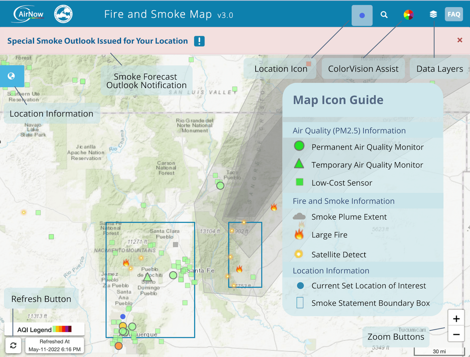
Setting a Location
Entering a location makes more information available to you. If you didn’t enter a location when you first opened the map, or want to change your location, click the icon on the upper right-hand corner of the screen. That will open a box where you can type in a location of interest. Selecting the blue dot icon: will return you to your set location. You can also drag the blue dot icon to a location of interest.
Making a favorites list
You can save locations by creating a favorites list. Here’s how:
- Click on a monitor or sensor, then click the “Add to Favorites” button on the lower left corner of the popup box. Do this for each monitor or sensor you want to add.
- After you’ve added the monitors or sensors you want to save, click the location icon (icon) on the left side of the page. You will see your saved locations.
- Click the “Bookmark” link. That generates a unique web address (URL) and opens a pop-up box where you can copy the URL to the clipboard.
- Open a new tab in your browser. Paste the URL you copied to the clipboard into the address bar, then bookmark it. Go to the bookmark each time you want to check the Map. You also can share the unique URL with others.
Need more help? See our User Guide available here
About the Data
The Fire and Smoke Map shows information on particle pollution, fires and smoke plumes:
Particle pollution data:- Particle pollution, also called fine particulate matter or PM2.5, is the main type of pollution in smoke.
- The Map shows particle pollution data from established air quality monitors
 operated by air quality agencies, temporary monitors
  deployed by agencies for smoke events, and low-cost sensors
  made by PurpleAir. These sensors are owned and operated owned by individuals, organizations and agencies.
 - The Map does not show other types of air pollution, like ozone, that also may affect your air quality. Visit AirNow.gov to see ozone information near you, or check your state or local air agency website.
- Note: Sensors sometimes report over- or underestimates of the actual amount of particle pollution in the air. Before sensor data appears on the Map, we apply an EPA scientific correction equation so you can compare sensor data to data from permanent monitors. Learn more about our data processing steps here.
Fire data- The Fire and Smoke Map shows two types of fires: large fire incidents
 , from U.S. National Interagency Fire Center, and satellite fire detections
  from various satellite systems.
 - Note: Satellites find fires by sensing temperatures on the ground and then looking for areas with the same temperature as a fire. False detections can occur in places with high ground temperatures or sun reflection. Satellites also routinely find multiple hotspots for a single large fire.
Smoke Plumes- Smoke plumes shown on the Map indicate that smoke is present. However, the smoke may be high in the air instead of at ground level.
- Note: The monitor or sensor icons on the Map always show air quality near ground level. Click a monitor or sensor icon to see how smoke is affecting the air you breathe.
Disclaimers:
- EPA does not use the data on this Map to make regulatory decisions.
- Mention of trade names or commercial products does not constitute EPA or USFS endorsement or recommendation for use.
- Always stay tuned to local authorities for the latest information on wildfires, smoke , and safety.
Learn more about the work that goes into bringing you the information on the Map. See our Frequently Asked Questions available here
Actions to Take
Monitor permanent: and temporary: icons and sensors icons on the Fire and Smoke Map show particle pollution in the color codes of the U.S. Air Quality Index (AQI). Click on an icon to see the NowCast AQI level at that location, and to see actions to consider taking.
The AQI has six categories, ranging from Good to Hazardous. The table below shows the actions you can consider taking for each category.
AQI Categories and Recommended Actions
| When the air quality is: | Actions to take |
|---|
Good
AQI 0-50 | Everyone: Don't see or smell smoke? It's a good time to open windows or go outdoors. |
Moderate
AQI 51-100 | Everyone: Don’t see or smell smoke? It’s OK to open windows or go outdoors.
Unusually Sensitive people: Keep outdoor activities light and short; go indoors if you have symptoms. |
Unhealthy for Sensitive Groups
AQI 101-150 | Everyone: Keep outdoor activities light and short.
Sensitive Groups*: Go indoors if you have symptoms. |
Unhealthy
AQI 151-200 | Everyone: Keep outdoor activities light and short. Go indoors if you have symptoms.
Sensitive Groups*: Consider moving all activities indoors. |
Very Unhealthy
AQI 201-300 | Everyone: Limit all outdoor physical activity. Go indoors if you have symptoms.
Sensitive Groups*: Avoid all outdoor physical activity. |
Hazardous
AQI 301+ | Everyone: Avoid all outdoor physical activity. If you are hot, go someplace with air conditioning.
Sensitive Groups*: Stay indoors in a place with cleaner indoor air, and keep activity levels light. |
*Sensitive (at-risk) groups include people with heart or lung disease, older adults, children, pregnant people, and people who spend a lot of time outdoors.Pay attention in extreme heat.
Extreme heat can lead to potentially deadly illnesses, such as heat exhaustion and heat stroke. If it is hot outdoors, and you feel hot indoors, go somewhere with air conditioning, if possible.
Want to learn more?
Find additional links and FAQs available here to learn more about wildfire smoke and your health.
Learn More
Use the above tabs to learn How to Use this Map, about Data that is shown on the map, and about Protective Actions you can take.
Want to know more about the Map and wildfire smoke and your health?
Visit https://www.airnow.gov/fasm-info to read:
- User Guide
- Frequently Asked Questions
Feedback
USFS and EPA continue to pilot improvements to the Fire and Smoke Map. We welcome your feedback.
Have a suggestion?Please email us at firesmokemap@epa.gov
 v3.2 Fire and Smoke Map